Mills and Bridges: a walk along the River Lossie
Friday, 10th April, 1pm, Sheriffmill, Elgin
Twenty members met in the car park at the Eight Acres Hotel for a guided walk along the River Lossie from the bridge at Sheriffmill, finding out about the mills and bridges, the industries and frequent flooding along the way. The walk was led by Club secretary Sara Marsh, who began with some basic facts about the river – length 31 miles, a short river by comparison with the Spey and the Findhorn, but an important source of water power for the industries of Elgin in the Middle Ages. The river has also caused major flood damage in the past.
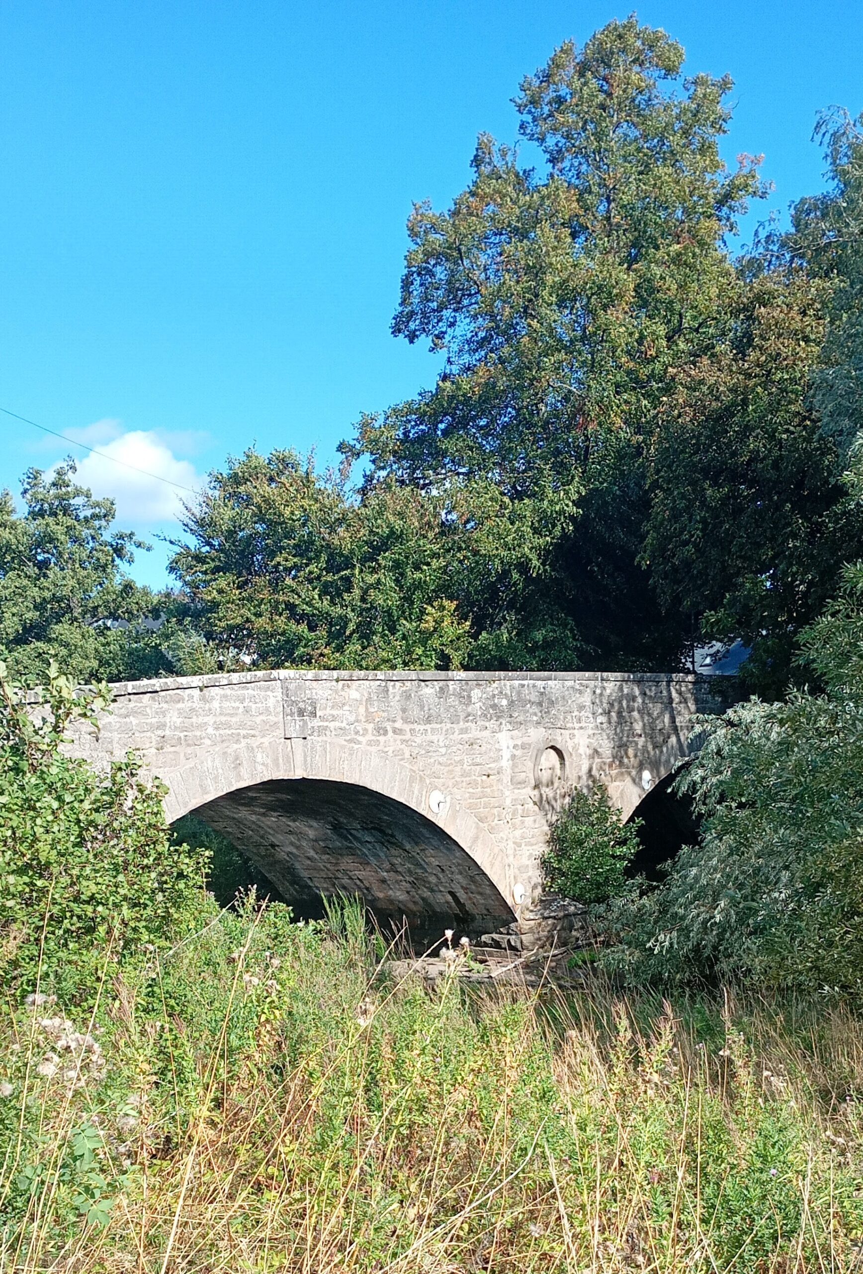
The walk began at Sheriifmill, the fourth bridge over the Lossie, after the Cloddach bridge (1905, now closed to traffic), Palmerscross bridge (1815, on the site of the ancient Palmerfuird, or pilgrims’ ford) and Connet Hill bridge (1956, as part of the reconfiguration of the A96). Sheriffmill bridge dates from 1803, part of the improvements initiated by Thomas Telford’s survey of the Highlands. The bridge was repaired in 1830 after being damaged by the flood of 1829. Apart from the weir, nothing remains of the watermill, the second mill on the river after Scroggiemill, a little upstream which has completely disappeared. Sheriffmill was granted to Walter de Moravia, sheriff of Elgin by the Bishop of Moray in 1237. This was a meal mill for most of its existence.
After leaving Sheriffmill, we made a short detour to admire two very different houses – Braelossie House (1863) built by Reid and Mackenzie for Alexander Lawson, the Earl of Fife’s factor, in Scottish baronial style, and across the road, Connect Hill house (1913) a fine Arts and Crafts Villa by Marshall Mackenzie.
Half way down Jock Inkson’s brae (named after tattie salesman in the first half of the 20th century) we stopped to talk about the devastating Muckle Spate of 1829 – a catastrophic flood which swept away buildings and bridges in Elgin and other parts of the north east. Subsequent floods have also been damaging including those of 1915, when New Elgin was cut off from the town and the railway line was under water. There have been five floods since 1997 which cause disruption to transport and evacuation of homes. In 2011, work began on the flood alleviation scheme, completed in 2016 at a cost of £86 million.
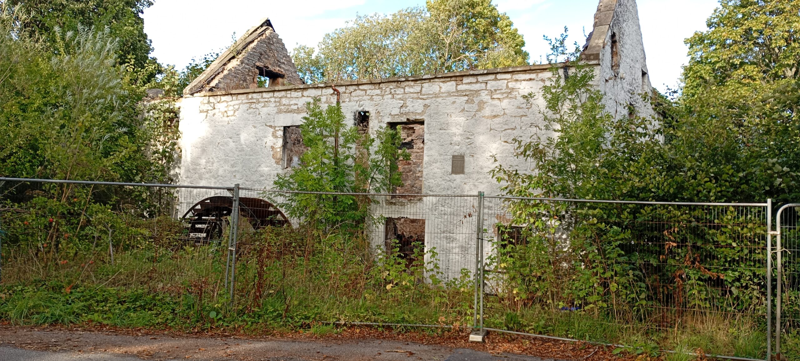
Our next stop was at the ruins of the oldest mill on the river, Kingsmills, or Old Mills, dating from 1010, and granted by Alexander II to the monks of Puscarden Abbey. After the Reformation, the Mill changed hands many times. The present building, what’s left of it, dates from 1794, as the previous mill burnt down in 1792. It was acquired by a local farmer in the 1960s, and in 1967 it was leased to Moray District Council. Restoration work took place between 1978 and 1984, and for twelve years Old Mills was a popular working museum. However the site was abandoned in 1997 and subsequently sold. The site became a rubbish dump and the grain store was destroyed by fire. In 2022, the Mill itself was gutted by a major fire and remains in the sad state we see today.
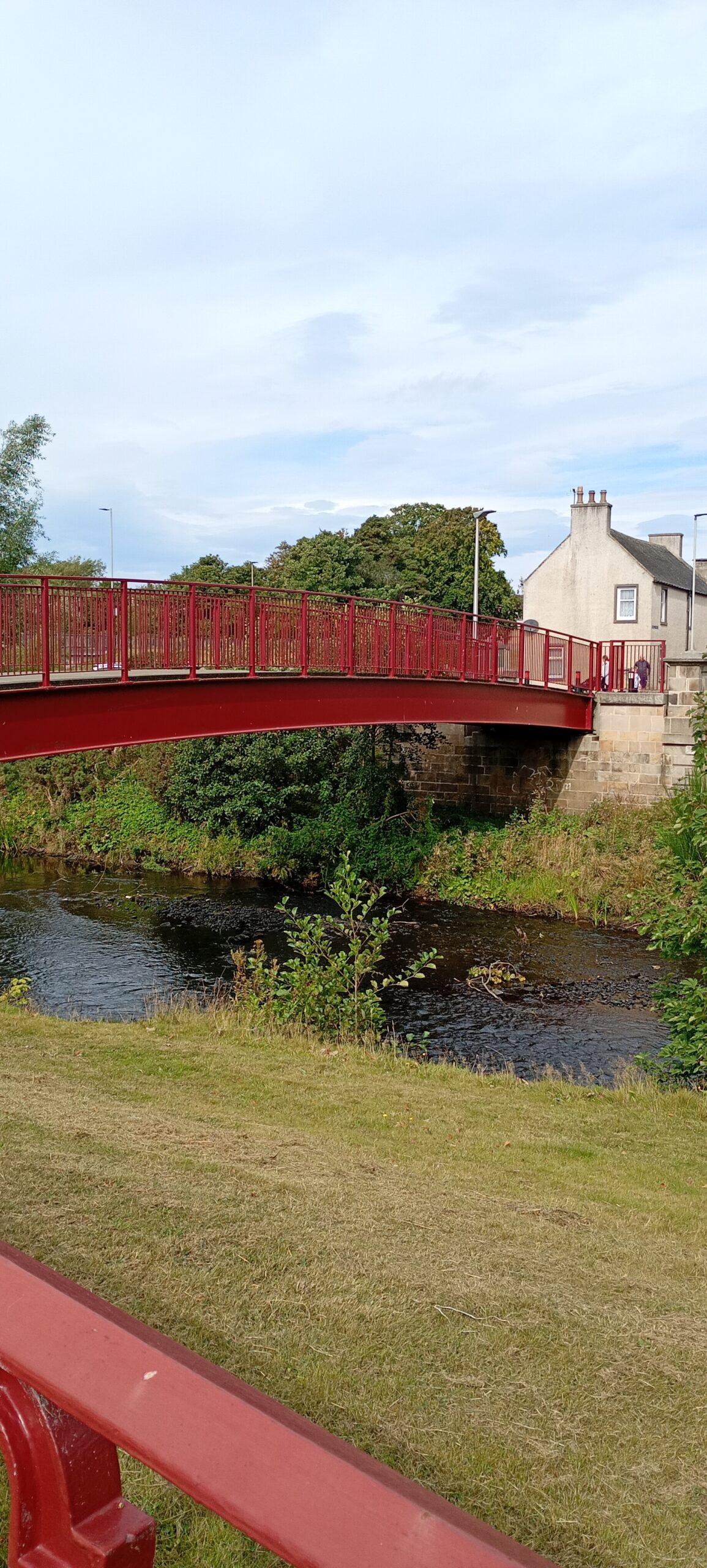
We continued our walk along Old Mills Road to the Bow Brig, built between 1630 and 1635, as recorded by an inscription on the bridge itself – FOUNDIT 1630 FINISHIT 1635. The bridge was solid enough to withstand the Muckle Spate. We followed an elevated path through the woods, passing the weirs which fed water into the Old Mills lade, down to river level and the sixth bridge, a new red bridge, constructed at the time of the flood alleviation scheme and forming part of the cycle path. The next bridge is the Marywell bridge, given by local banker in 1870. The name Marywell refers to the natural spring on the footpath on the other side of the river. The path, known as Ladies’ walk follows the riverbank, with the King George V playing fields or Morriston Playing fields on the left. This area was known as the Haugh -an area of flat meadowland on the flood plain of a river. On the other side of the river and connected by the green Morriston Bridge (1930s) was Blackfriars Haugh, the site of a large and prosperous monastery, of which no trace remains. It was demolished after the Reformation, and any remaining buildings were razed to the ground in 1750. The house known as Blackfriars Haugh was built in the nineteenth century and after a varied history is now a hotel.
The footpath/cycle path continues through the area now known as Boroughbriggs. The river has changed its course since the Middle Ages and once flowed due east from Morriston. The area was prone to flooding and unsuitable for building, though the Moray Leisure center was opened in 1993. Boroughbriggs is now synonymous with Elgin City Football Club, founded in 1893. The path passes under the ninth bridge on the river – Bishopmill Road Bridge (1988). Next to it is Bishopmill Old Bridge or the Red Bridge (2015, replacing the 1871 bridge). The fourth mill on the river – the Bishop’s Mill – dated from the beginning of the thirteenth century, and continued as a flour and meal mill until 1877, when it was bought by Ramsay and Reid and became a textile mill – Lossiebank Mills – run by Reid and Welch until 1980. The McWhirter family bought the premises and transformed the Mill into a DIY store and garden centre – Decora. Its history is remembered in the name of the cafe – the Millers’ restaurant.
It was here at 3pm that our walk ended with a cup of tea and a scone in the cafe. There are still three bridges and three mills to explore …….. To be continued